Overview
The Victorian Deer Control Program (DCP) is providing grants to support deer control and management actions in priority areas to prevent or minimise the impact of deer on our high priority values in Victoria, guided by the Victorian Deer Control Strategy (VDCS).
As prescribed in the Victorian Deer Control Strategy (VDCS) and the Regional Deer Control Plans (East, West and Peri-urban), funded activities will address the issues of deer impacts to protect biodiversity, cultural heritage sites, water quality, agriculture and to increase public safety by reducing deer collisions.
Projects
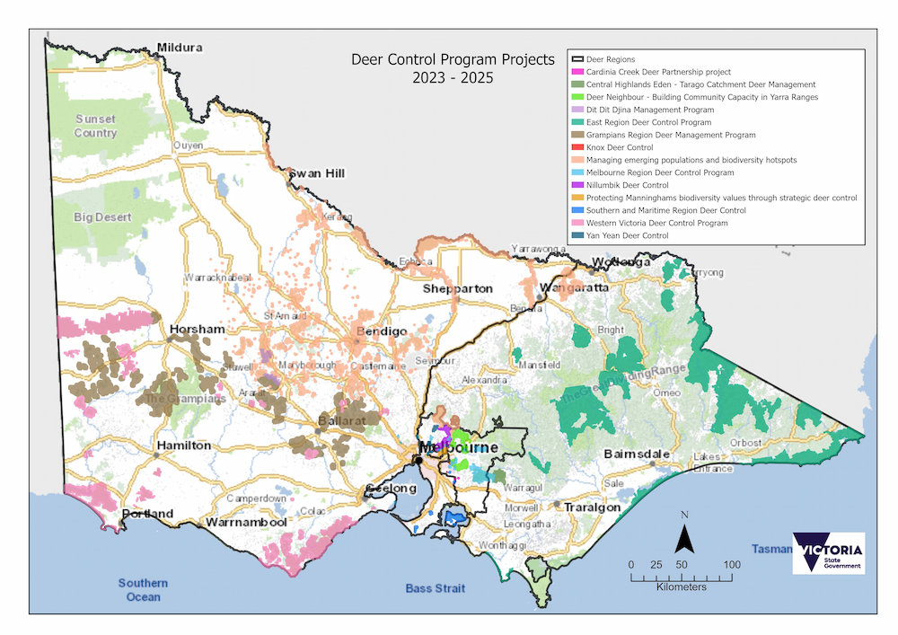
Deer Control Program Projects 2023 - 2025
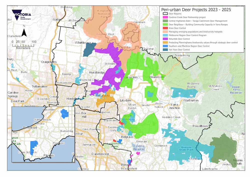
Peri-urban Deer Projects 2023 - 2025
The Cardinia Creek Catchment Deer Partnership Project is a Cardinia Shire Council lead program aimed at delivering deer control and monitoring in the Cardinia Creek catchment to protect extensive areas of intact, high value remnant vegetation, including riparian corridors.
Sites in the Cardinia Creek catchment have been identified by the Helmeted Honeyeater Recovery Team (DEECA, Zoos Victoria) for future releases of Helmeted Honeyeater (Lichenostomus melanops cassidix) and project activities are being guided by habitat requirements for this species.
Professional deer control is to be conducted at Berwick Montuna Golf Course and Cardinia Beaconhills Golf Course and will complement similar works being conducted by Parks Victoria. Control will contribute to protection of biodiversity in the adjoining parkland, as well as reducing damage by deer at the golf course.
Project lead: Cardinia Shire Council
Project lead website: Cardinia Shire Council
Project lead contact: 1300 787 624
The Central Highlands Eden - Tarago Catchment Deer Management - project takes a collaborative approach and builds on the Central Highlands Eden tenure-blind weed management program. The core project area encompasses Tarago Reservoir, and parts of Tarago River Forest Reserve and Labertouche State Forest, with works also extending to adjoining freehold properties where ground shooting can be safely undertaken.
Ground shooting funded by Victorian Government immediate deer control funding and a Melbourne Water Liveable Communities, Liveable Waterways grant has seen 319 deer removed to date. 2023-25 funding will facilitate continued deer reductions and consolidate efforts to protect key water quality, agricultural, Aboriginal cultural heritage values and environmental values, including the Gippsland Spiny Crayfish, Tall Astelia, Gully Grevillea, Tree Geebung, Filmy Maidenhair and associated vegetation communities.
Project lead: DEECA Port Phillip Region
Project lead website: Victorian Deer Control Program (environment.vic.gov.au)
Project lead contact: 136 186
The Northern Region deer control program will control and reduce established populations of deer to protect key biodiversity hotspots across North Central Victoria, including the IUCN green-listed Warby Ovens National Park, RAMSAR listed Barmah Forest and Barmah National Park, and Kinglake National Park.At a landscape scale, the program will manage emerging populations within priority areas and containment zones identified in Regional Deer Control Plans and in line with the Victorian Deer Control Strategy and National Feral Deer Action Plan. These projects will identify, monitor, and disrupt pathways for deer dispersal across the landscape, prevent the establishment of populations in new areas, and provide a platform for a rapid response approach to new incursions across Parks Victoria estate.
Project lead: Parks Victoria
Project lead website: Deer (parks.vic.gov.au)
Project lead contact: 13 1963
These diverse landscapes are all being impacted by Fallow and Sambar deer through grazing/browsing, tree rubbing, trampling, and wallowing. SSAA and ADA volunteers shooters will assist with deer control programs at Cardinia Creek Parklands, Lysterfield Park and Devilbend NFR. Whilst professional control contractors will also undertake work at all of these locations, as well as Mornington Peninsula NP. This control work will support local community control work, reduce the vehicle collision risk on surrounding roads and contribute to protecting species such as the Growling Grass Frog, Lewins Rail and the Swamp Skink.
Project lead: Yarra Ranges Council
Project lead website: Yarra Ranges Council
Project lead contact: 1300 368 333
Djandak will develop a management plan for a Kara Kara National Park and Pyrenees State Forest, with the primary objective of reducing populations of Dit-dit- Djina (Djaara language for hard-hooved invasive pests) to protect cultural and ecological values. By implementing monitoring, controlled shooting, data analysis, and compliance with ethical guidelines, our aim is to mitigate the adverse impact of deer populations on cultural heritage sites, prevent overgrazing of native vegetation, and preserve the integrity of waterways.
Project Lead: Dja Dja Wurrung Clans Aboriginal Corporation
Project Lead Website: Djaara (Dja Dja Wurrung Clans Aboriginal Corporation)
Project Lead Contact: 03 5444 2888
Deer control using ground and aerial shooting is conducted across eastern Victoria to reduce impacts to biodiversity, Aboriginal cultural heritage values, water quality, agricultural assets and public safety.
The presence of deer reduces the health of native ecosystems and habitat including EPBC listed alpine peatlands and Rainforest Sites of Significance. Deer destroy native vegetation through trampling and browsing and outcompete native wildlife for food sources. They contribute to degradation of waterways and spread weeds and pathogens which impact the health of native species. Deer control locations are determined by presence of high value environmental assets and their susceptibility to deer damage. Ground shooting will be delivered at night-time in and adjacent to critical high value areas. Aerial control is utilised across large and remote areas which are difficult or unsafe to access by foot. Continuing broad scale deer control will reduce impact on threatened flora and fauna species, critical habitat and significant ecological vegetation communities across the landscape, including Baw Baw Frog, Pookila and Littoral Rainforest.
Project lead: Parks Victoria
Project lead website: Deer (parks.vic.gov.au)
Project lead contact: 13 1963
Results from the 2022-2023 Grampians Aerial Reconnaissance Project indicated where deer populations and densities are highest. Based on those results and further planning and analysis, aerial and ground control will be combined in targeted areas to undertake asset protection measures across State Forest and adjacent tenure. Deer control will focus on areas where deer are impacting biodiversity and other values, degrading water and stream bank quality through wallow use, browsing and damaging regenerating and threatened species, and contaminating town drinking water catchments. The project will collaborate for cross-tenure delivery of control measures and ongoing monitoring with Parks Victoria (PV), Game Management Authority (GMA), Hancocks Victoria Plantations (HVP), Traditional Owners and community stakeholders /special interest groups and professional volunteers across the central west of Victoria. The project area includes forests and reserves from Edenhope near the South Australian border, across Mt Cole in the central region, to the forest around Trentham in the east.
Project lead: DEECA Grampians Region
Project lead website: Forest and road closures (ffm.vic.gov.au)
Project lead contact: 136 186
The biodiversity team at Knox City Council aims to continue funding an ongoing deer control program as well as build upon the current pest monitoring and management strategies within the municipality of Knox. These actions aim to reduce the current and potential negative impacts deer have on threatened flora and fauna and habitat with significant ecological value. They are currently having damaging effects by ring barking trees, shrubs and eroding the banks of important creek lines potentially home to platypus. The predicted outcomes of this project include: Reducing the impacts of deer on key environmental, agricultural and Aboriginal cultural heritage areas and public safety. Provide community education activities to encourage future community driven efforts. Reduce the likelihood of deer further spreading into peri-urban areas with a particular focus on The Basin and Lysterfield regions. Monitoring the occurrence of deer within the municipality to further inform pest control strategies.
Project lead: Knox City Council
Project lead website: Knox City Council
Project lead contact: 03 9298 8000
This project will focus on deer control with the aim of reducing their impacts on valuable protected and remnant landscapes in peri-urban Melbourne. By reducing the number of deer, funding will be supporting the recovery of valuable listed plants and fauna. The Superb Lyrebird is one species that is being impacted by deer in the Dandenong Ranges National Park. Deer impact the quality of Lyrebird habitat, destroying nesting sites and leaving them more exposed to predators by the removal of the forest midstorey. Melbourne region projects will also provide for collaborative works with a number of local shire councils, Landcare groups and community groups. This will also provide the opportunity to reduce the impacts of deer on adjoining agricultural land and reduce the vehicle collision danger on a number of peri-urban roads.
Project lead: Parks Victoria
Project lead website: Deer (parks.vic.gov.au)
Project lead contact: 13 1963
The Nillumbik Deer control Project is a collaborative and strategic peri-urban ground-based deer control project. Managed by Council, it covers over 13,000 hectares of largely privately owned land. The works support the protection of Nillumbik’s high value biodiversity and agricultural enterprises; and help to contain the flow of deer from Kinglake National Park and along waterways and habitat corridors to the Yarra river and beyond.
Project lead: Nillumbik Shire Council
Project lead website: Nillumbik Shire Council
Project lead contact: 03 9433 3111
Manningham Council’s protecting Manningham's biodiversity values through strategic deer control project will control the impact deer are having across private and public land to a range of values including biodiversity, agricultural, waterways and catchment and public road safety values. Manningham LGA is biodiversity rich supporting around 22 per cent of Victoria’s known plants, including the threatened Wine-lipped Spider Orchid and Round-leaf Pomaderris, which are impacted by deer browsing, and indirectly impact species such as Platypus through erosion and sedimentation of our creeklines. As well as threatened species, deer are having serious impacts to the vegetation structure and regeneration of a huge variety of native shrub and tree species throughout our sensitive creekline ecological vegetation communities. Changes to the forest structure and habitat impacts many fauna species in particular birds, insects and mammals essential for pollination and will have serious long-term impacts on the heath and function of these ecosystems.
Project lead: Manningham Council
Project lead website: Manningham Council
Project lead contact: 03 9840 9333
Project lead: Parks Victoria
Project lead website: Deer (parks.vic.gov.au)
Project lead contact: 13 1963
Parks Victoria’s West region parks and reserves are situated across a large and varied landscape that includes Geelong to the border and as far north as Little Desert National Park. The west region deer control project area will focus on protecting key assets directly threatened by deer. This includes the biodiverse Anglesea Heath, part of the Great Otway National Park which contains 70% of all of Victoria’s plant species including several critically threatened flora and fauna species and significant cultural assets such as the world’s oldest aquaculture site, located in the UNESCO World Heritage Site, Budj Bim Cultural Landscape. The control programs will target deer using both aerial and ground shooting programs on Parks Victoria managed land and on approved adjacent private land. This interface work will help reduce impact from deer on surrounding agricultural and horticultural land including plantations, dairy pastures and vineyards. Where feasible, the deer carcasses will be harvested and taken to a commercial processing facility.
Project lead: Parks Victoria
Project lead website: Deer (parks.vic.gov.au)
Project lead contact: 13 1963
This project is an extension of the Deer Control Program 2022-24 at Yan Yean Reservoir (October 2022 – February 2024) and aims to reduce the population of wild deer within the Yan Yean catchment by undertaking a ground control program from May - December 2024. The current population is over grazing the catchment vegetation, threatening the long-term survival of important remnant indigenous plant populations. The desired outcomes of this program include increased protection to endangered flora species, protecting water quality and reducing microbial contamination risk to the general public, reducing spread of invasive weeds, asset protection, reducing fire risk through preventing long-term ecological changes and reducing illegal shooting.
Project lead: Melbourne Water
Project lead website: Melbourne Water
Project lead contact: 131 722
Page last updated: 29/08/24